India, Burma, and Ceylon

ele-geog.htm
by Henry Francis Blanford, F.R.S,
Late Metrological Reporter to the
Government of India, Macmillan & Co.,
London & New York, 1890, pp191.
-
http://books.google.ca/books?... 130103
Downloaded versions in TIL HD-PDF and SD-PDF libraries:
-
HFBlanford-ElemGeoIndBurCey<Ô> /
Bkp<Ô> (link chk 190501)
-
HFBlanford-GeoIndBurCey<Ô> /
Bkp<Ô> (lin chk 190501)
Downloaded and set in html by U Kyaw Tun (UKT) (M.S., I.P.S.T., USA), and staff of Tun Institute of Learning (TIL). Not for sale. No copyright. Free for everyone. Prepared for students and staff of TIL Research Station, Yangon, MYANMAR: http://www.tuninst.net, www.romabama.blogspot.co
Bur-Myan spellings in Myanmar script and Romabama are included. Romabama spellings are within { }, and regular English words within < >. You'll need only Arial Unicode MS font to read these files. Any other Unicode font may not display the characters correctly.
index.htm | |Top
earth-indx.htm
| geog-indx.htm
UKT 130104: Based on my interest I have divided this presentation in three parts. Part 2, dealing with Burma and Adaman-Nicobar island groups in which Coco-Islands are now included in Myanmarpré, is my interest. Parts 1 (with most of the pix) and 3 (without any pix) are at present only of cursory interest.
UKT 190509: Now only after a long lapse, I'm continuing work on this page.
Preface
01.
The Indian Empire : Burma was part of in the Indian
Empire before Separation
-----Participants from Burma had to wear Indian
turbans at International events
01.01. Influence of
India's Geography on its People
01.02. Geographical Position
Outer Form, Size, and Boundaries
General Surface Features
Climates
Plants and Animals
UKT notes
•
Original TOC
•
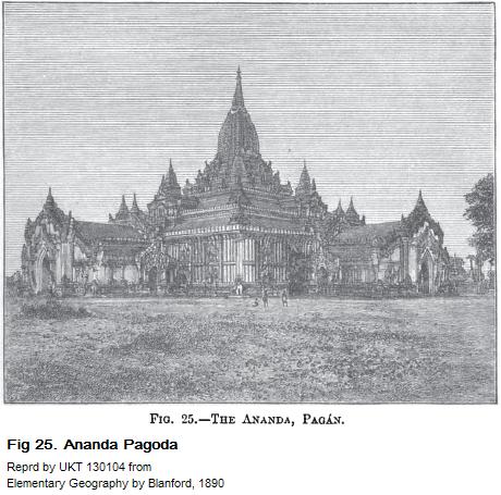
Images from the first part
• Images from Burma : p162
•
Images from Adaman and Nicobar islands : p 175 |
• Ceylon : p177 (not started)
(p-roman05)
In this little book the geography of the
Indian Empire is described on the same general
plan as that adopted by Dr. Geikie in his
Geography of the British India , but
with much modifications as were found
necessary in dealing with a country far more
extensive, diversified, and unfamiliar in
most its aspects. [UKT ¶]
In order to bring so large a subject within the modest limits of less than 200 pages, it has been necessary to restrict the descriptions to such features as are most characteristic and important, and it has not been possible to enter into much detail. Teachers and others who may require such for their own information may readily obtain it in Dr. George Smith's excellent Students' Geography of British India, in Sir W.W. Hunter's Indian Empire, and especially the Imperial Gazetteer of India, and the numerous articles in the ninth edition of the Encyclopedia Britannica. Elphinstone's History of India, edited by Professor E.B. Cowell, is perhaps the best work of reference for the history of the Indian people under their Hindu and Muhammadan rulers, and for the elucidation of such few historic allusions as are to be met with in these pages. And for a philosophical insight into the character and social condition of the people of India, no work can compare wtih Sir Alfred Lyall's Asiatic Studies.
(p-roman06)
In the course of long service in India, the
author has had occasion to visit most parts
of the Empire, and much of the general
description of the country and its provinces
is either based on or controlled by the
results of personal observation. But of course
the great mass of the information, has been
taken from other authentic sources, and
the author is also indebted to several
friends for additional information on
certain subjects for which his own means
of references were insufficient.
The statistics of areas, population, etc., are given chiefly for comparison, and in order to inculcate true ideas of proportion, not for the purpose of burdening the pupil's mind with tables of unmeaning figures.
The illustrations are for the most part taken from photographs. Many of those of the natives of India have been copied, wtih the courteous permission of Dr. Rost, the chief librarian of the India Office, from the beautiful series collected by the Government of India. It is due to Messrs. Cooper and Sons, the engravers, to testify to the truthfulness of their reproduction as woodcuts.
In the spelling of Indian names, the authorized lists issued by the Government of India have been followed. The principle on which these lists have been drawn up is that the names of well known places that have acquired a fixed English spelling, such as Calcutta, Delhi, Lucknow, Cawnpore, etc, are written in the usual form. In the case of others, the native spelling is followed more or less closely in so far as the elemental sounds, can be represented by English letters. By attention to a few simple rules the proper pronunciation of these names can be easily mastered.
Consonants have the same sound as in English, observing that g is always hard as in gig ; ch has the same sound as in church ; and sh the ordinary English sound as in shall . Except after these two letters h is always an aspirate, and the consonant that it follows is aspirated.
(p-roman07)
The accent is thrown on the accented syllable :
á always has the same sound as in
father ; é that of a
in mate or ê in the French même ;
í that of ee in feel ;
ó that of o in pole ;
and ú that of u in rule
or oo in pool .
The unaccentuated a has generally the sound of u in but , or better , that of the o in button ; e that of the e in met or of the French é in the été ; i that of the i in fill ; o that of o in folly ; and u its sound in put .
These rules of course do not apply to Anglicised names nor do they to those of most of most places in Burma, but Indian names of objects and technical terms, such as pipal , pandit , rath , vihára , Khádar , etc., are spelt and should be pronounced according to the same system. [UKT ¶]
It is to be regretted, perhaps, that the system of accenting the long vowels has not been quite rigorously adhered to, since the u in the final syllable pur ( púr , a town), so common in Indian names, though unaccented is a long vowel, and the first A in Aligarh is long, but not the second. [UKT ¶]
In a few instances, also, the official lists are discordant in the different provinces. Thus the rivers Són , Gandak , Mahánadi , etc., of the Central Provinces and the North-West Provinces appear as the Soane , Gunduk , Mahanuddy , etc., in the Bengal list. In such cases both forms are given in these pages.

UKT 190505: Blanford Cuts: View as 150% and crop to 700pix.
(p001)
We speak of India as a single country, because it is under one supreme
government [colonialist government of British Indian Empire]; but it is really a collection of many countries, differing from each
other in soil, climate, and productions, in the races that occupy them, in the
languages, religions, and civilization of their peoples, and in many respects.
[UKT¶]
Yet no country is more distinctly marked off by natural boundaries. Although it forms a part of Asia it is nearly cut off from the remainder of the continent by the great mountain chain, the Himalaya, on its northern border, and the almost equally lofty, cold, and barren table-land of Tibet beyond; while its southern half projects into the Indian Ocean, and is bounded on both sides by the sea. On the north-east and north-west also it is enclosed by mountains, but these are less lofty than the Himalaya, and the countries beyond them are not so high and barren as Tibet. From both these quarters immigrants and invaders in past times have penetrated to India, and especially from the north-west, the frontier of Afghánistán and Balúchistán. But India is most accessible from the sea; and for centuries past, and more than ever at the present day, it has communicated with other countries chiefly from its coasts.
(p001cont)
Owing to the fertility of its soil and the industry of its inhabitants, it is
one of the most productive countries in the world, and of the most densely
peopled; from very early times it has carried on as an important commerce,
exchanging its natural products and manufactures for those of other countries.
In this respect (p001end-p002begin) it resembles
Britain. But whereas the foreign sea-trade has been founded and carried on by
the inhabitants of the country itself, that of India has been left almost
entirely in the hands of foreign sailors; formerly the Arabs and the Greeks, and
now those of the whole civilized world, especially the British.
UKT 190505: The phrase "the whole civilized world, especially the British" showed the arrogance of the Europeans and North Americans, who take that everything that is top begins in the West. It is this attitude that has brought down the Greeks and Romans, and the British. I wonder whether it is cause of the beginning of the decline of the Americans and Canadians at the present.
The explanation of these and many other important facts in the present condition and past history of the people of India is to be found, partly, at least, in the geography of the country. [UKT¶]
That India is so richly productive is richly productive is owing to the vast extent of its fertile plains, and to its climate, which is one the warmest on the surface, while most parts receive a sufficient and some a very abundant rainfall; this combination of circumstances being that which makes agriculture easy and very profitable. And this productiveness, on the one hand, has attracted immigrants and invaders from the poorer countries beyond its frontier, and on the other hand, has fostered trade, which consists in different countries or provinces exchanging with each other so much of their productions as are not required for the consumption of their own inhabitants. Hence the inhabitants of the towns and cities of India have long been keen traders, carrying on an active inland trade between the different provinces. How is it, then, that India has produced on race of sailors, like the Arabs, to carry her superfluous produce to distant countries ? (fn002-01)
The answer to this question will probably be that the Hindu religion discourages traveling by sea. And this is no doubt true, but the explanation is far from complete. (p002end-p003begin)
-----
fn002-01 It must not be understood from these
remarks that there are no Indian sailors, nor that in past times the Hindus have
always abstained from sea travel. At present indeed the Indian seafaring
population (fishermen and boatmen excepted) is almost entirely Muhammadan; but
centuries before the advent of Muhammadans, there was an active coasting trade
as at present, which must have been carried on by Hindus; and the conquest of
Ceylon by Wijáyo from Bengal, and the colonisation of Pegu and Java by Telingas,
from the shores of the Godávari delts, show that the Hindus must have had
considerable intercourse with these countires many centuries before the
Christian era. The statement in the text is, however, not invalidated by these
facts. - fn002-01b
-----
(p003)

It is generally found that customs that have been sanctioned by the popular
religion, and seem to have been imposed by it, have ...
this is not so. Strong sea-currents run up or down the coast at different seasons of the year, and have caused all these rivers to form bars (fn003-01) across their mouths, rendering the entrance so shallow that only small boats can pass into them, and therefore they are useless as habours for sea-going ships.
Even more than for its natural productions and costly (p003end-p004begin)
-----
fn003-01 See Physical Geography for Indian Schools, chap. viii. - fn003-01b
-----
(p004)
(p-roman09)
01.
The Indian Empire -- 001
Influence of India's Geography on its People
Geographical Position
Outer Form, Size, and Boundaries
General Surface Features
Climates
Plants and Animals
Population
Languages
Religion and Caste
Products, Industries, and Commerce
Internal Communications
The Government of India and its Provinces -- 047
The Supreme Government
Provincial Governments
Native States
Foreign Possessions
The Provinces of India -- 050
Balúchistán
Kashmir
The Punjab
North-West Provinces and Oudh
Bengal
Assam
Rájaputána
Central India Agency
Central Provinces
Bombay (p-roman09end-roman10begins)
Berar
Hyderabad
Mysore and Coorg
Madras
Burma -- 162
Andaman and Nicobar Islands
Ceylon
Foreign Possessions in India -- 182
Frontier States -- 184
Afghánistán
Nepal
(p-roman11-roman12)
List of Illustrations

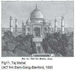
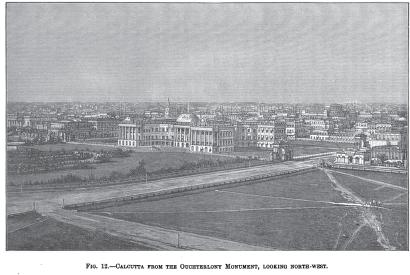
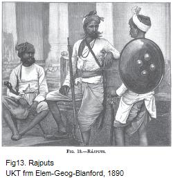
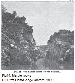


Reprd by UKT 130104 from
Elementary Geography by Blanford, 1890
(p162)
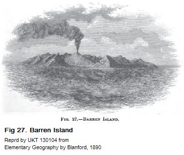
Barren Island coordinates: 12.27 deg.N., 93.85 deg.E.
--
http://en.wikipedia.org/wiki/Barren_Island_Andaman_Islands 130104
(contd from p177)
End of TIL file